
 TARRANT COUNTY, TX
 Tarrant County Archives
Bess Smith Broderick Collection
Summary: The Broderick Collection is made up of photographs, correspondence and business records of the donor's father, Sidney Smith, in relation to his business - particularly the Cicero Smith Lumber Company. The collection includes oil field maps used by the donor's husband, Al J. Broderick (1895-1942) in conjunction with his oil business, Calvert and Broderick, and correspondence related to that business.
Photographs
- Candid photograph of George Livermore and party, December 9, 1941. Notation in ink on back of one copy. Location unknown. Two prints.
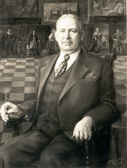
- Cecil Calvert, copy from oil portrait by Boris Luban, 1940, black and white (image shown). According to entry in "Oil Legends", George Calvert was in the process of assembling a collection of family portraits to display in the family home outside Washington D. C. Accompanying the photograph is correspondence from Joseph Wheeler, Librarian at Enoch Pratt Free Library, Baltimore, to George Calvert, Fort Worth, dated March 27, 1945
Correspondence and business records
- Arkansas Louisiana Gas Co.
- Consolidated Mining and Milling
- Income tax returns (1924-1931)
- Mexican contracts related to Consolidated Mining and Milling
- Correspondence, Panola County
- Pecos County, Independent Oil and Gas Co.
- Eagle Mountain Lake property
- Various deeds to Sidney Smith
- Financial statements for Cicero Smith Lumber Company dated 1926, 1929, 1930, 1931, 1932, 1933, 1934
- Various deeds and business papers for Sidney Smith and Mrs. Ella Smith
Maps
- Oil Map for North east Texas (1931) compiled by the Oil Weekly
- Oil maps for Anderson County: North, Roeser area, section, and Blackfoot Area (Acme Map)
- Oil maps for Andrews County: Zingery, Southwest mapping (January 1943),
Cowden Royalty - Oil map for Brown County: Logan map
- Oil maps for Clay County: Heydrick map, 1947
- Oil maps for Coleman County: Heydrick map (1927), two structural maps of Weaver Ranch (1928), Northeast Coleman County (1927)
- Oil maps for Crane County: Southwest mapping (1941), Zingery, Crane and parts of Pecos County (Zingery, 1942)
- Oil maps for Ector County: Southwest mapping (1937), Zingery map (no date), Zingery map (1926), map of Cowden Royalty (1947), Zingery (1940), Southwest Mapping (1943), Zingery (1942)
- Oil maps for Gaines County: two Zingery (1928), Zingery (1942), Zingery (1938)
- Oil maps for Howard County: Zingery map (no date)
- Oil maps for Panola County: Acme map (1936), M H West map (no date and torn into two sections), map of Smith land holdings drawn by S H Hunt, (1917), two copies of plat of Frost Lumber Company lease (1936), map of Mrs. Sidney Smith's subdivision in Leach and Soape surveys (1936), portions of two maps of county, two maps of southeast Panola County, Murvaul Drilling Block, one negative map of a portion of County, one written field note for Mrs. Sidney Smith's part of Ashton survey. (1939)
- Maps for Rusk County: S H Hunt survey of part of County (1918)
- Oil maps for Ward County: Edwards Bros. Ranch, Ward County (no date)
- Oil maps for Winkler County: Zingery (1938), royalty map by Zingery (1929), Zinger map (no date), portion of Southwest map for 1948 used for estate tax purposes.
- Oil map for Wise County: Heydrick maps 1937
- Lake Bridgeport, Fort Worth Water District map, 1930
- Panola County
- Pecos County, oil map (Zingery)
- Odessa Plat map (for Broderick and Calvert)
- Van Zandt County, (middle third of County, undated)
- Van Zandt County, Van area (Zingery-Gulf Map Co., undated)
- Van Zandt County map, Broderick and Calvert