
 TARRANT COUNTY, TX

 Tarrant County Archives
Tina Walls Collection

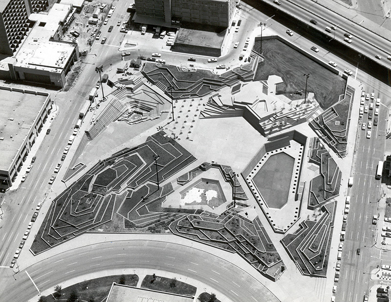
Summary: Donor was a local representative for Cole's Criss Cross Directories. Collection includes volumes of city directories from 1959-2008. Also included in the collection are 61 photographs of buildings and other sites taken in the 1950s through 1980s as well as maps of the Dallas/Fort Worth area. Images shown (left to right) are Tandy Center (now City Place) in 1980 prior to the construction of what is now the Tarrant County Plaza Building and the Fort Worth Water Gardens under construction in 1973.
View the Tina Walls image gallery.
Directories
- City Directory: Dallas, 1981
- City Directory: Fort Worth, 1959, 1961-1980, 1985-1986, 1988, 1992-2006, 2008
- Tarrant County (government) Telephone Directory, February 1, 1973
- Tarrant County Rural Directory, Rural Directory Service Inc. Fort Worth, Texas, June, 1954
- 1990 Census Tract Supplement for Fort Worth, Cole Publications
- Texas Business Directory, The Ultimate Sales and Credit Tool. Three volumes, 1997-1998
Photographs
Sixty-one photographs of sites in Fort Worth and Arlington, mostly taken or controlled by W. D. Smith Inc. Commercial Photography. Unless otherwise noted, all are eight by 10 inch, black and white glossy prints.
- Fort Worth Children's Museum, 1501 Montgomery. Photo by John A. Stryker, 1950s
- Implosion of Aviation Building, Trans American Life. Built 1930, designed by Herman P. Koeppe of Wyatt C. Hedrick firm. Northeast corner of 7th Street and Main, Fort Worth. Four by three inches; Imploded July 23, 1978
- U. S. Federal Building and Post Office, Fort Worth, Jennings Ave. This photo not made by W. D. Smith, but is one he owned rights to by buying entire collection of an earlier Fort Worth photographer. Circa 1900
- Fort Worth skyline, taken from roof of Rotary Apartments at 7th and Summit Avenue, looking east down West 7th Street. 1936
- Fort Worth skyline, taken from roof of Rotary Apartments. Apartments were razed soon after. 1977
- Texas & Pacific Railroad Passenger Depot, Lancaster Avenue, between Main and Jennings Avenue, building built in 1931. Wyatt C. Hedrick, Architect, 1944
- Texas & Pacific Railroad Passenger Depot, frontal shot from Lancaster, 1944
- Implosion of buildings prior to building Tarrant County Convention Center. Location: 14th and Main, Fort Worth. Buildings identified: Big Ben's Pawn Shop (Bennie Luskey), 1411 Main Street; Dutch's Place restaurant, 1400 Main Street; Main Hotel, 1407 Main Street; Palm Hotel, 1413 Main Street; Melvin's Loans, 1417 Main Street, 1964
- Aerial view of downtown Fort Worth, prior to I-35, Tarrant County Convention Center, Tandy Center, and Sundance Square development, 1966
- Hotel Texas, photo of architect's rendering of hotel with new addition across on Commerce Street, 1967
- Hilton Inn, 1800 Commerce Street
- Southwestern Baptist Theological Seminary, established in 1908, Seminary Drive, 1970
- Pedestrian Walk-through from Continental National Bank to its parking garage across Sixth Street, 1972
- Six Flags Amusement Park, Arlington, on Dallas-Fort Worth Turnpike, 1971
- Six Flags Amusement Park, Arlington, 1972
- Fort Worth Police Department Helicopter Patrol, 1970
- Glen Campbell concert in Tarrant County Convention Center, 1970
- Seven Seas Park, operated by City of Arlington, drawing, 1970
- Seven Seas "Sea Lion Theatre" drawing, 1970
- Seven Seas "Entrance Cave" drawing, 1970
- Roller Skating Penguins, Seven Seas Park, drawing, 1970
- Turnpike Stadium and Seven Seas Park, Arlington, 1972
- Fort Worth City Hall, central fountain, 1972
- Fort Worth Central Business District, aerial view, from W. Lancaster Ave. looking northwest, before building of Fort Worth Water Gardens. March 31, 1972
- Fort Worth Central Business District, aerial view, from Vickery looking north east, Fort Worth Water Gardens being built. 1972
- Fort Worth Central Business District, aerial view from 15th Street looking north. Demolition for Fort Worth Water Gardens still taking place. circa 1971
- T & P Railroad train yard, from Bryant Irvin looking east to University Drive. Circa 1972
- Fort Worth Central Business District aerial view, from east side (near Terrell High School) looking west, Fort Worth National Bank completed. 1973
- Poster for Fort Worth centennial (of incorporation, by Roy Lee Ward), 1973
- Fort Worth Central Business District, aerial, from 16th Street looking north east, demolition still being done to make space for Fort Worth Water Gardens. Circa 1971
- Rolling Hills Water Treatment Plant (City of Fort Worth), Loop 820, 1973
- Bank of Fort Worth, 600 Bailey Avenue, 1973
- Dallas-Fort Worth Regional Airport, 1974
- Fort Worth, aerial view of Central Business District, from Summit Avenue looking east, before construction of I-35W; Ryan Building (Summit Plaza) under construction at Summit and Lancaster. 1974
- Fort Worth Water Gardens, aerial view, designed by Philip Johnson, before landscaping, before Monnig Warehouse changed to Water Garden Place. 1974
- Will Rogers complex and Cultural District, aerial view from University Drive looking north west, before building of North Texas TCOM, Fort Worth Public Health Center at bottom of photograph. 1974
- North East Shopping Mall, with US 183 and Texas 121, and Loop 820 above mall. North Richland Hills, 1974
- Thistle Hill, home of Electra Waggoner Wharton and Winfield Scott. "Save the Scott Home" campaign, 1509 Pennsylvania, Fort Worth, 1976
- Dallas-Fort Worth International Airport, 1976
- Fort Worth from east side, showing Dallas-Fort Worth Turnpike, I-35 W has not been started. H. H. Butler Public Housing on right of photo, 1977
- Hulen Mall, aerial view, 1977
- Fort Worth Central Business District, aerial view from Vickery looking north, northwest. Fort Worth Water Gardens are completed, Medical Arts Bldg. has been torn down. 1977
- Night time view of Fort Worth, during Christmas season, with buildings' rims illuminated, from west side, possibly from Amon Carter Museum porch, two Tandy towers with candlelight motif of left part of photo, Montgomery Ward store below them, Fort Worth National in center, with CNB clock tower shining. 1977
- Western Place, 6151 Pershing, headquarters for the Western Co. of North America, Preston Geren and Associates, Architects, 1977
- Loop 820 bridge over Lake Worth, looking north east, grain elevators at Saginaw are visible at top of photograph, 1977
- Ridgmar Mall, Fort Worth, 1977
- Comanche Peak nuclear power plant for Texas Electric Service Company, Hood County, 1978
- Comanche Peak nuclear power plant, TESCO, 1978
- Seminary South Shopping center, (I-35 West and Seminary Drive), an open air mall, 1978
- East Exchange Ave., Fort Worth Stockyards, 1978
- Log Cabin Village, 2100 Log Cabin Village Lane, Forest Park, Fort Worth, 1978
- Japanese Gardens, Fort Worth Botanic Gardens, 1978
- Pate Museum of Transportation, Texas Refinery Co. Ranch, South Central Swap Meet Association. 377 South, near Cresson, April 27-30, 1978
- Fort Worth National Bank (John Portman, architect), two Tandy center buildings (Martin Growald, architect), YWCA (old Elks Club), Fort Worth Public Library and Main Street buildings before Sundance Square begun (Monnig Department Store, W. C. Stripling Department Store and Leonard's are all visible, Ripley Arnold Public Housing at top along Belknap Street.), 1978
- Western Place I and II, 6000 Western Place, Fort Worth, home office for the Western Company of North America, Geren and Associates, architect, 1979
- Fort Worth Hilton Hotel, 1701 Commerce, Fort Worth (later a Ramada Inn), showing hotel after remodeling, adding 175 rooms, 1980
- Hyatt Regency Fort Worth (formerly the Hotel Texas, later the Radisson), 111 E. 8th Street, showing plans for remodeling after purchase by Woodbine Co. (Ray Hunt of Dallas), 1980
- Equitable General Insurance Group, Twin Towers, at Hulen Street by T & P RR bridge, Fort Worth, 1980
- Bass Towers, 1 and 2, Paul Rudolph, architect. Built 1982
- Americana Hotel, built by Bass Brothers Enterprises, Paul Rudolph, architect, 1980
- Mrs. Baird's Bread plant, South Freeway (I-35 West), in Carter Industrial Park, 1980
Maps
- Mail Marketing Maps of Dallas-Fort Worth, Texas (six maps), two sets. Metro mail Corporation, circa 1990
- Buying Power Map of Fort Worth, Texas and Vicinity, from 1990 Census. Nine pages, 1992
- Hand-drawn maps on tracing paper, done by Ms. Walls, of rural postal routes in Tarrant County, circa July 1979
- Grapevine, Routes 1, 2, and 4
- Euless, Route 1
- Bedford, no route number given
- Route 3, delivered from Glencrest Station (Everman)
- Route 4, delivered by Handley Station
- Route 5, delivered from Ridglea Station (south of Benbrook, north to US80)
- Route 7, delivered from Glencrest Station (Kennedale, Rendon)
- Route 8, delivered from White Settlement Station (White Settlement and Lake Worth)
- Route 9, delivered from Saginaw Station (Meacham Field north to Denton County line, including Bond Ranch, Eagle Mountain)
- Route 10, delivered River Oaks branch, (Jacksboro Highway north to Ten Mile Bridge)
- Route 11, delivered from White Settlement Station (White Settlement area west of Loop 820, north of I-30)
- Route 12, delivered from Glen Crest Station (Kennedale area)
- Route 13, delivered from Glen Crest Station (Kennedale-Arlington area, east and west of Mansfield Highway)
- Route 2, 76135, delivered from River Oaks Station, west of Loop 820 south of Jacksboro Highway
- Route 1, Saginaw Post Office, west of I-35W, Industrial Boulevard, north to Hwy 114
- Six Mail Marketing Maps of Dallas-Fort Worth, Texas, undated
- Northern suburbs of Dallas (Collin County, Rockwall)
- Irving, Grand Prairie, Lancaster, Mesquite, Garland
- portions of Parker, Wise and Denton Counties
- portions of Tarrant County: Fort Worth, Arlington, Hurst/Euless/Bedford, Grapevine
- portions of Ellis and Kaufman Counties
- portions of Hood and Johnson Counties
- Bentley Village, Preliminary Plan, Section No. 2. Gordon Swift, Consulting engineer, July 6, 1976
- Bentley Village Addition, Section 1. J. H. Williams and Associates, consulting engineers, April 1974
- Stonegate No. 2, Section 2, Carter and Burgess, engineers and planners, 1968
- Roads around Lake Worth, City of Fort Worth, August 27, 1962
- Rural Routes maps, Route 2 (76135), Route 4 (76112), Route 7 (76119), Route 8 (76108), Route 10 (76135), Route 12, undated
- Keller (76248) streets added to the Keller Section in the Roanoke Section (76262)
- Existing city streets in Crowley, circa 1970s
- Mail Marketing Maps for Dallas and Fort Worth (six maps). Metromail Corporation
- U. S. Post Office Zip Code Boundaries: Tarrant, Wise, Denton, Dallas, and Johnson Counties, 1990, 1991, 1996
- Census Tract Information for Dallas and Fort Worth markets, circa 1990
- Fort Worth, Rand McNally, late 1970s
- Official Guide Map Wedgwood and Candleridge, Fort Worth, Texas, 1977
- Map of Hurst Euless Bedford and Vicinity, Chamber of Commerce for Hurst, Euless and Bedford, 1976
- "Welcome to Arlington," Ebby Halliday Realtors, 1984
- Alliance Area Economic Development Map, The Business Press, 1989
- "Welcome to Burleson," Burleson Area Chamber of Commerce, 1982
- "Welcome to Burleson," Burleson Area Chamber of Commerce, 1985
- Street Map and Business Directory for Azle, Texas and Vicinity, 1960
- The Official Map of the Hurst, Euless, Bedford Chamber of Commerce, 1974
- Map of City of Everman, Tarrant County, on linen. Undated
Miscellaneous
- The Fort Worth Business and Professional Women's Club Bulletin, June 30, 1942, September 15, 1942, September 22, 1942, September 29, 1942, October 6, 1942, October 13, 1942, October 20, 1942, October 27, 1942, November 3, 1942, November 10, 1942, November 17, 1942, November 17, 1942, November 24, 1942, December 22, 1942, January 5, 1943, January 12, 1943, January 19, 1943, January 26, 1943
- City of Fort Worth stationary, Van Zandt Jarvis, Mayor, 1934.